Walking Bauma - December
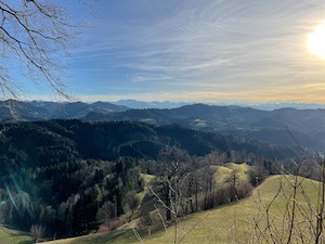
With a lovely winters day forecast, but unfortunately not enough snow to go snowshoeing nearby, Jules and I headed to Bauma to do the circular walk from the favourite Rother book: Rund um den Zurichsee, #15.
We hadn't done this walk in a couple of years, and last time in sub-optimal weather, so we were keen to seeing the views. The route climbs steadily out of Bauma through light woodland and then into more open countryside higher up. We seemed to remember the route well enough, but the Gasthof at Sternenberg had been completed since we last passed this way. We stopped in for a coffee and were very pleasantly surprised - it's been really nicely done inside, and very welcoming.
After a good Kuchen for Jules and an oversized ice-cream for me, we headed on for the last climb - taking the Hertz und Lunge detour at the top of the hill. The views were lovely, and the visibility was very good - only a hill in the way preventing it from being a Säntis to Pilatus day. Descending from the top, we looped back to Bauma to finish a good stretch of the legs on a fine winters day.
Overall it was 14.1km, with 500m ascent descent and took us 3 hours 50, including the break in the Gasthof. It's a T1+ and the gpx plot of our route is here.
Walking Ehrendingen to Endingen - December
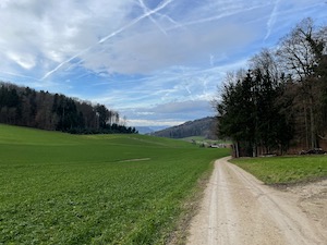
With a slightly overcast but mild day forecast, Jules and I headed over to Ehrendingen to do a recommended walk to Endingen. We didn't want to travel too far, and I wasn't feeling 100% after a nasty cold, and this gentle walk seemed like a good option.
It was an easy journey by train and bus, and we were soon heading off up the first (gentle, but still exhausting for yours truly) climb. The route winds through fields, countryside, and woods and we suspect that in better weather the views over the Jura & Bernese and Western Alps would have been spectacular. We saw a deer very close by (Jules being good spotter), and a green-finch but otherwise it was pretty quiet. One highlight was seeing llamas eating Christmas trees - and apparently very happy to do so!
It was a lovely & gentle walk, and we must go back when the weather is better and we can enjoy the views properly. Overall the 12.2 km with 190m ascent / 300m descent took us 2 hours 30 (including a brief stop at the hofladen), and it's a pretty easy T1. The gpx plot of our route is here.
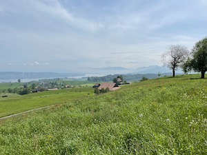
Walking Stäfa to Rapperswil - December
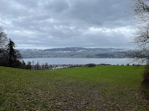
With a grey and slightly dull but dry day forecast, Jules and I braved the (unforecast) rain to do walk number 51 from Wanderungen in der Schweiz 2021/2022 - Über dem Zürichsee.
The route starts at Mühlehölzli above Stäfa and follows the ridge heading south parallel with the lakeside. Despite the grey skies we were treated to views of Pilatus & Rigi, and further on Speer and the Glarner group.
Near the Lützelsee the route joined and merged seamlessly into Jules’ favourite Storchen walk [cough], and from there we continued along the ridgeline above the vineyards. We stopped at the hofladen at Schwesterrain where Jules bought possibly the most expensive chocolate truffles in Switzerland plus some apple juice. From the hofladen the route drops down and loops to the finish in Rapperswil, where we were pleasantly surprised by the local Christmas market on the waterfront. We stopped for some Glühwein, a burger, and some other bits & pieces from the stalls.
Not including the Christmas market, the 13.4km with 170m ascent and 370m descent took us 2 hours 50, and we'd rate it a T1. The gpx plot of our route is here.
Walking Wildegg to Aarau - December
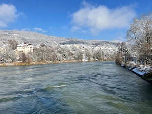
With a cold but sunny winters day forecast, Luis and I met up in Wildegg to do an easy walk along the Aare to Aarau, finished off with a visit to the Christmas market.
It was a little cloudy when we arrived in Wildegg, but it brightened up steadily as we progressed. The walk itself is very gentle following the Aare upstream. We noted that there was a lot of flow in the river (to our slight surprise), and the snow covered trees made for a pretty backdrop.
We saw a buzzard and a heron en-route, and even two people preparing for a swim, which we thought was rather brave! We made good progress to Aarau whereupon we headed to the Christmas market to warm up with a plate of Momos - an excellent choice after a long walk. We rounded off with a cheeky beer in the Irish pub before heading back to our respective homes.
Overall it was 11.2km, and took us 2 hrs 50 minutes all in. It's an easy T1, and the gpx plot of our route is here.
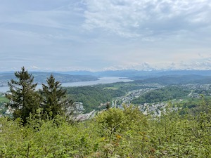
Walking Pilatus - September
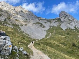
With a great day forecast, and dry for the previous week I decided to take the opportunity to walk up Pilatus. The route I chose was from Eigenthal up and over the peak and down to Alpnachstand.
The journey to the start was pretty easy, albeit the bus was very full with people taking advantage of the weather and heading up to Eigenthal. Upon arrival I was slightly embarrassed to realise we’ve been to Eigenthalerhof before, but never-mind. The route climbs steadily through mixed woods for the first 5km, until the base of the proper climb. I decided to take a little rest and have some lunch before heading up, which was probably a good idea.
The main ascent was quite busy. This is clearly a popular route on a lovely day, but everyone was friendly despite climbing at different speeds. I counted 24 people ahead of me at the start of the switchbacks, and a similar gentle line all the way to the top. The route climbs fairly steeply to the church at Klimsenkapelle, then up the last stretch to the complex at the top.
The peak and hotel was pretty full, but I guess that’s to be expected. I made a quick trip up to the trig point at Esel and took a couple of photos before heading down on the descent.
The path on the descent was a bit slippery with loose-ish scree and slightly hard work. The route start with bare mountainside,eventually giving way to woodlands, before emerging in bright warm sunshine just above Alpnachstad.
Arriving at the bottom I had quick wash-up and the decided to have a relaxing beer instead of racing for the train. A good decision, I think! Overall the route was 17.8km with 1150m ascent and 1750m descent. It's a T2 and it took me 5:55 all in, but without many breaks or stops. The gpx plot of our route is here.
Zurich Seeüberquerung - August
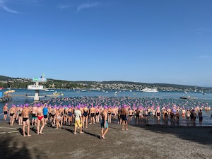
With a bit of planning and preparation I managed to get ticket for the Zurich Seeüberquerung, for the rescheduled date in August.
I picked a start in one of the later groups, and headed over to Strandbad Mythenquai in the late afternoon. The warm-up was hilarious, but probably a good idea for those participating. It was pretty warm on the day, and I was quite grateful that the sand by the lake was being showered to keep it cool before we entered the water.
I swam at a pretty relaxed pace, trying to take the time to enjoy a different (lower) view of the lake and surroundings. It took me about 50 minutes for the 1,500m crossing, so definitely not setting any records!
I arrived at the Badi Tiefenbrunnen shortly after Jules, and was surprisingly grateful for the hot bullion and risotto that was served up. We stayed for a bit of refreshment in the badi before heading back home. Overall it was an interesting and different experience and I'm pleased that I did it, but I'm not sure I'll rush to do it again.
Walking Federispitz - August
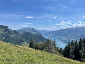
With a lovely day forecast and keen to get out for a walk but without travelling too far, I headed down to the Walensee to walk up Federispitz from Ziegelbrücke.
The route climbs pretty relentlessly from the train station at Ziegelbrücke. Starting out in woods and farmland then turning into more open mountainside. It was quite hard work in the sun and heat, but compensated by lovely views down the Glarus valley, over the Walensee, the Churfirsten, and Saentis in the distance. The route starts to get more tasty on the ridge-line up to Plättlispitz, before becoming slightly easier round the almost-horseshoe to Federispitz. I stopped for lunch just below the peak then continued along the Federigrat ridge before dropping down to Obernätenalp. From there the route retraced my steps back down to Ziegelbrücke.
I was only carrying just about enough water for a very hot day - I finished the 3.75l well before the end of the walk, which is worth remembering when there no huts en-route. I found the walk quite hard-going (perhaps a little tired and worn-down) - it's one of those walks with hardly any flat sections - steep up and then steep back down with almost no respite. It was hot for most of the way, only gentle breezes at the top, and very hot dry wind once back to the lower slopes. I had to buy an alcohol-free citrone Radler at the kiosk at the station - which did not last long! I saw a red squirrel, lots of lizards and butterflies and of course kites en-route.
It's a pretty decent walk - 15.1km with 1450m of ascent/descent and took me 6 hours 5 minutes including breaks and lunch. The gpx plot of my route is here.
Walking Bubikon (Störchen walk) - June
Keen to get out for a good stretch of the legs, and to drag Jules away from studying, we headed to Bubikon to walk route #12 from Rother Rund um den Zurichsee.
It's been a while since we last did the full walk, so it wasn't very fresh in our minds. We chose to do the route anti-clockwise this time and set out in glorious sunshine.The weather was very kind to us - bright and sunny for the whole walk - but the views over the mountains a little hazy. A summer thunderstorm was brewing in the Glarus valley by the end of the day, but we finished before it reached us.
We saw plenty of kites and buzzards, a kestrel and even a very large fox. Of course we saw lots of storks, including a nest with what looked like three large babies, which must have been almost ready to fledge. The badis we saw were full with people enjoying the summer weather and the countryside was full of life.
We arrived back at Bubikon to find the car in shade (to our considerable relief!), and to finish off a very good walk. We did realise that we probably weren't carrying enough water. We didn't seem many fountains en-route, but there were a few cafes and hofladens. Overall the 17.3km with 250m of ascent/descent took us 3 hours 45 including one short break for a drink and a slice of cake. It's a T1, and the gpx plot of our route is here.
Walking Bachtel - May
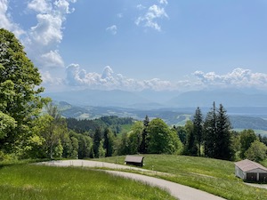
With a lovely bright and warm day forecast, and the feeling that summer had finally arrived, Jules and I headed to Wald to walk up the Bachtel.
We arrived in bright sunshine and, after a brief struggle with the SBB P+rail app, we headed off up the hill. Despite the route starting out pretty steeply Jules was determined to race up the hill and yours truly almost had to run to keep up. We were treated to slightly hazy views over the Zurisee about one-third of the way up, then the Glarus valley and Speer a little further on.
We stopped at the Restaurant Bachtel for a quick drink and then headed on. We weren't quite sure which route to take, but decided to carry on further away from Wald. We followed the ridge and stopped for a picnic lunch near Stüssel and there decided to carry on all the way to Steg, approximately the same as one of our first ever walks in Switzerland.
After lunch we continued to follow the ridge to Schlosschopf where we dropped down to Steg. We were quite warm by the time we arrived and took an ice cream from the bakery in Steg to the station to wait for the train back to Wald.
This is a lovely route, without too much travel and nicely variable in terms of length with three different length options to return from the top of the Bachtel. The views are fantastic when the visibility is good, and it’s a proper stretch of the legs without being too onerous. Overall the 16.4km with 710m or ascent and 630m of descent took us 4 hours 35 (including the stops for a drink and a picnic lunch) and we'd rate it a T1+. The gpx plot of our route is here.
Walking Sihltal - May
With a lovely afternoon forecast, and keen to fit a walk into Jules’ study schedule, we headed down the Sihltal to try a variation on #45 from the favourite book Rund um den Zurichsee - "Über den Hirzel nach Sihlsprung".
The forecast turned out to be accurate - the first properly nice summer’s day of the year. We began at the old Sihlbrugg station in glorious sunshine and headed up the usual steep climb at the start and then more gently through Bruppacher and into Zimmerberg. We departed from the usual route in the centre of Hirzel and instead turned right towards Chalbisau. We stopped for a short picnic lunch on a lovely bench just outside Hirzel with views over the Rigi and Pilatus. From there we dropped down into the Sihltal to join the usual path just a little downstream of Sihlbrugg.
This is a nice variation on the longer walk, with easy navigation and quiet paths despite there being quite a few people out enjoying the good weather. It was a proper Säntis to Pilatus day, the kites were out in force, and we even got to see a kestrel hovering over the field whist we had lunch. Jules was very excited to spot some orchids near the end of the walk by the Sihl, particularly as this would have been the traditional weekend for the family orchid walk.
Overall the 11.7km with 420m of ascent/descent took us 2hrs 50 minutes (including the brief stop for lunch). The gpx plot of our route is here.
Walking Hedingen to Adliswil - May
With a rare good-weather day forecast, Jules, Luis and I headed off for a relatively short walk from the yellow Zürcher Wanderwege: Wanderungen in der Schweiz 2023/24 # 127 - Albisquerung.
The route starts in Hedingen, which is fairly easy to get to by train from Zürich. From the station the route heads up the hill quite steeply at first and then more gently through rolling hills winding upwards to the Adlis ridge. We've been in this part of the canton a fair amount, but this was a new route for us. However, the navigation was quite easy, and the route was very quiet. We called in to a Hofladen near Hinterbuchenegg where I picked up some fruit tea, which turned out to be rather good. We stopped for slightly longer at the restaurant Felsenegg for a refreshment and a bite to eat before continuing down the steep track to Adliswil to finish. We were pretty pleased with the route - a good stretch of the legs without being a long journey or too challenging.
Overall the 10km with 400m of ascent and 450m of descent took us 3 hours 5 minutes, including the stop for at the restaurant Felsenegg. It's a T1+ and the gpx plot of our route is here.
Walking Richterswil - Etzel - Pfaeffikon April
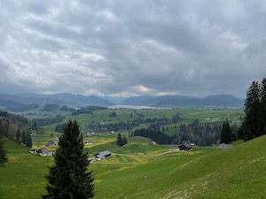
With the spring weather continuing pretty marginal, but keen to get out after a few weekends stuck indoors, Jules swapped her study days around to make the most of the good weather. We headed off to try a walk from this year's Zürcher Wanderwege: Wanderungen in der Schweiz 2023/24 # 55 - Etzel
It was our first decent walk in a while, so we decided to take it fairly gently. The route climbs steadily out of Richterswil, heading out through villages first then farmland and eventually up into woodlands & hillsides. After the main climb the route heads around the back of the Etzel, before descending to Pfaeffikon along the route we’ve done a few times before.
The weather was fairly kind to us and in-line with the forecast - it stayed dry the whole way, with even some sunny spells. The mountains were a little obscured by low clouds, but we caught some nice views of the Sihlsee and Einsiedeln village. The dandelions were out in force in the meadows, and there was still some very pretty apple and cherry blossom in the orchards.
Overall it's a pretty good walk, a short distance from Zürich by train and very easy. The 17.5km with 640m ascent took us 4hours 30 all in, and the gpx plot of our route is here. We were pleased that our legs held up without any problems at all.
Walking Olten to Aarau - February
Keen to get out for a stretch of the legs, Jules and I headed over to Olten to meet up with Diana & Luis for a walk along the Aare to Aarau.
It was a somewhat bracing when we arrived at Olten. There was a fairly stiff breeze and only 1°C, so it felt pretty cold until we got moving and warmed up a bit. We followed the usual route out of Olten until the weir separating the canal from the river. Here we decided to take the route along the canal for a bit of a change from last time.
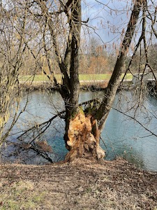
We saw a kingfisher en-route, but he was a bit shy of having his photo taken. We also saw lots of evidence of beavers, which are supported and protected along this section of the river.
It was gently snowing when we arrived in Aarau, and we stopped for a coffee to warm up a bit before heading off home. This is a good stretch of the legs, with very easy navigation and no challenges. The 14.9km took us 3 hours 25 including one stop for a tea & flapjack, and it's a flat T1. The gpx plot of our route is here.
Winter Walk Studen - February
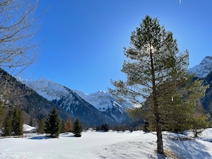
Taking advantage of a stunning winter's day, Jules & I headed over to Studen to check out the loipe and to have a stretch of the legs.
The walk we chose was the shorter, flatter route with a chance to see loop #5 (orange) of the loipe. The route heads up the valley on the far side of the stream heading towards the woods and the base of the valley sides. The scenery is very pretty in this quiet part of the world particularly in bright sunshine and with very large snow/ice crystals on the ground. It was a very relaxed and easy walk, but we considered it enough to have earned a wurst at the Langlaufzentrum when we finished!
Overall it was 5.8km and mostly flat. The gpx plot of the exact route we took is here, on the day the route was marked slightly differently from the official paths in some places.