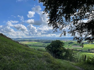
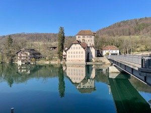
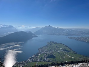
Walking Uetliberg - December
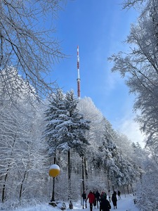
With a lovely day forecast and fresh snowfall overnight, Jules and I headed up to the Uetliberg to do the classic walk along the ridge to Felsenegg.
We weren't the only people with the same idea - the train was pretty full of families heading up the hill with sledges. However, the crowds thinned out pretty quickly once we were underway, and we were soon walking with just the usual traffic for the route. It really was a lovely day for a winter walk - bright and sunny but cold and with snow covered trees. It was however a bit slippy underfoot in places, and we both did the comedy "ice-shuffle" in places.
We made gentle by steady progress to the paragliding take-off point at Balderen where we paused to take away a fortifying Glühwein, after waiting in line for a very well-behaved Labrador. Arriving at Felsenegg we popped in to look at the Restaurant Felsenegg, but it was very full, and instead we took the gondola down.
Overall the 6.75km with 225m ascent/descent took us 1 hour 40 in the conditions on the day - not rushing at all.
Walking Wisenberg & Bad Ramsach - October
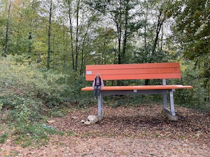
With a lovely autumn day to look forward to and keen to see the leaves changing, Jules and I headed back to the Aarau Juras to try Route #7 from the Rother book Schweizer Jura: Wisenberg & Bad Ramsach.
We drove to Rümlingen and then started up the hill. The route climbs pretty steadily from under the railway bridge up past Häfelfingen and then continues on up to the top of Wisenberg. It was a bit windy at the top, so we didn't hang around, and instead started on the descent through the woods.
We stopped for a very good fitness teller as a light lunch at the hotel Bad Ramsach, although we were a tiny bit surprised by the 5% "temporary energy surcharge" on the bill. Predictably the route headed back up the hill after lunch (it’s a walk that keeps on giving) before looping back past the Ruine Homberg and the oversized chair back to the start of the walk.
It's a good autumn walk, with the trees in all their splendid colour. The rolling hills of Baselland are very pretty and the route takes in the many views both north and south. Overall the 16.4km with 750m of ascent / descent took us 4 hrs 40 including the stop for lunch, although we were going at a pretty steady pace.
Walking Geissflue - October
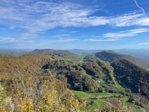
With a lovely day forecast, Jules and I headed to Aarau with Diana and Luis to try route #3 "Geissflue" from the Rother book: Schweizer Jura.
We parked at the edge of Erlinsbach and walked up to the start of the walk at Breitmis where we met Diana & Luis. The route heads up past Ramsflue and on to Wasserflue where we were treated to spectacular views along the length of the alps. Saentis to Pilatus was only about a third of the distance we could see - it really was spectacular to see, and we weren't the only ones up there enjoying the view.
From Wasserflue the route heads along the ridge to Salhöhe then continues along to Geissflue. We stopped for a picnic lunch just past Salhöhe (the lentil rolls were a hit - worth remembering for packed lunches), and then a coffee just a little past Geissflue. We had a slight navigational error from the published route and had to go a bit cross-country to get back on track, but recovered in time for a drink in Barmelhof.
It was a lovely day for the walk. The weather was very kind to us, and the trees were in their full autumn colours and lovely to see. Worth remembering this one for autumn or spring on a clear day.
Overall it was 15.8km with 800m ascent/descent, and we’d rate it a T1+. It took us 6 hours all in, including the stops for lunch, coffee, and a drink. The gpx plot of our route is here.
Walking Albis Ridge - October
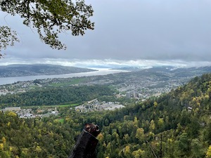
With the weather forecast a bit marginal, but keen to get out for a gentle stretch of the legs, my father and I headed up to the Uetliberg to do the classic walk along the Albis ridge.
We decided to take the train up to Uetliberg and to continue on past Felsenegg and down if we were feeling up to it. It was pretty grey with misty drizzle when we started, unfortunately deteriorating to proper wind-blown rain as we progressed. Fortunately we were carrying the right equipment (although no lederhosen for yours truly, which would have been perfect) so stayed pretty warm and dry. We did stop at Felsenegg for a warm bite to eat, and to get out of the weather for a bit.
The weather brightened up a little in the afternoon as we continued along the ridge eventually dropping down to Langnau. We caught the train back to town, and stopped for a well-earned refreshment to round out a slightly inclement but perfectly pleasant walk
Overall it was 11.4km, with 260m of ascent and 450m of descent, which took us 2hrs 55 (including the break for lunch). It's a T1+ and the gpx plot of our route is here.
Walking Frauenfeld - September
Wanting to get out for a gentle stretch of the legs, but nothing too strenuous or challenging, Jules and I headed to Frauenfeld to try walk #105 "Stählibuck" from yellow book Wanderungen in der Schweiz 2022/2023.
The published route heads out from Matzingen, past Schloss Sonnenberg, through Stählibuck, then drops down along the Mülitöbeli the heads into Frauenfeld.
We drove to Frauenfeld, then took the train the short way to the start at Matzingen. The route quickly leaves the village then heads through farmland and small woods heading up the hill to the castle at Sonnenberg (where repairs continue). The route continues through similar countryside and along small streams, passing the tower at the top of Stählibuck then dropping more steeply through and beside the woodlands. We were treated to musical accompaniment from a lone piper near Rüti - quite a talented player, lovely and unexpected to hear.
The route was exactly what we hoped it would be. It was 12.4km with about 380m ascent and descent and easy navigation on good paths. It took us about 2 hrs 45 minutes all in, and we'd rate it a T2- and a lovely day out. The gpx plot of our route is here.
Unfortunately we arrived at the Brauhaus Frauenfeld just after they closed so weren't able to take any beer away. We commiserated with a drink in the Altstadt before heading back home.
River Swimming Bern - August
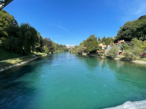
With a warm sunny day forecast, and the Aare in good condition for swimming, I decided to head to Bern to try out a few of the recommended routes.
I started with the Lorraine pool route. It was an easy walk from Bern station, heading across the old town centre and dropping down to the river. There weren't many people in the water, but after waiting for a few minutes I saw a couple go past - which gave me a bit of confidence that I was in the right place and not about to do something completely ridiculous! The river is quite easy and gentle at that point, and it's a nice drift down to the Lorraine bad. I had been slightly concerned about knowing where to get out, but honestly you can't miss it. I agree with the bern.com guide that its gentle and suitable for those less confident with being in the river. Additionally, the Lorraine bad is a very convenient place to dry off or in my case to put your shoes back on. The route is about 1.3km long, and I was in the water for about 16 minutes.
Enthused and emboldened, I headed over on foot to the Bremgarten loop. It wasn't very far and pretty easy to find my way there. I found the tunnel and the entry point to the river without concern. There was no-one else around when I got in (I figured out why a bit later), and my overall impression is that it's a much more secluded, quiet, and wild route with nature all around. It's also a much more technical route, with some very shallow parts, and some big rocks to avoid. I did get one hard bang on the left knee, and I had to walk a short section because it was too shallow and fast to be comfortable. That's probably the reason I was the only one swimming the route! That run was 1.7km and took me 25mins (including the walking).
Having come all the way to this area (and to take full advantage of the tunnel), I decided to have another go. This time I used my goggles and spent much more time swimming gently rather than just floating. This was definitely more interesting and a better option for me. I even saw some fish! My guess would be barbel given the size, shape and a glimpse of whiskers, but I only had a brief glimpse and couldn't be sure. I did find that the shallow sections are more intimidating in goggles - being able to see the bottom flying past isn't necessarily very reassuring, so I walked a bit more of the route this time which took a bit longer. It was fun to do this route, but I'm not sure that I'd rush to go back. I'd be tempted to try it with more depth to the water but that would presumably mean even faster through the shallow sections, so I dunno...
For my final run I took the bus back to town and then the tram to Wabern to do the Eichholz to Marzili bad route. I walked upstream quite a long way from the campsite, all the way to the island where the chain ferry crosses. There's a decent entry point from the most-downstream point of the island, although a bit of commitment is required when getting in. I used my goggles again on this run, which is definitely much better for me. I also tried to swim against the flow a bit, but no chance of going any direction other than backwards! I think I've found my most preferred setup to date - river bag secured around my waist with a long-ish line, and actively swimming in the river with goggles. I'm very happy being able to dive down to the bottom a bit, and I actually find it less effort than trying to stay afloat. The route itself is great - the 3.5kms took me about 30 minutes, and it's an interesting and fast flowing route but without any danger of hitting the bottom. Of the three, I think this is my favourite.
To finish the day I relaxed in the badi Marzili and dried off in the sun before heading back home. It was a lovely day out, and I must remember to take my goggles for future trips...
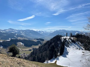
Walking Rigi - August
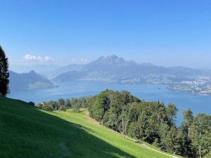
With a good day forecast and keen to do a decent walk despite not being in Meglisalp, I headed over to Schwyz to try route #16 from Rund um Zürich by Rother. This is a T3 linear route that heads up and over the Rigi before dropping down to Arth Goldau.
I made my way to Weggis by public transport, which is a bit of a trek but not too complicated. I started from the bus stop by the lake, and headed up the hill. The route climbs first through farms and farmland before heading into steeper woodland, eventually joining the Blumenpfad at Chänzeli with lovely views out over Pilatus and the Alps. The route up wasn't particularly challenging, it climbs steadily but quite a lot is in the woods and shade, and there is a pretty looking Hütte at Alp Räb at a convenient point for a break. From Chänzeli it’s just another 350m of ascent along the classic route by the side of the railway line up to the Kulm.
I stopped in the restaurant at the Kulm to eat some cake (I felt as though I deserved it), and to re-hydrate a bit. I then headed down the T3 section off the side face of the Kulm. The ground there was a bit loose and slippy, so I took my time and made it down the first tricky 100m without any incidents at all. From there it was a much easier walk-out, dropping steadily down to Arth Goldau on well-made paths and tracks. I was very pleased to see a Kestrel hovering over a field a little way past Zingelalp.
I arrived at Arth Goldau a little tired but very pleased with the day. Overall it was 18.5km with 1330m ascent and 1250m descent. It took me 5 hours 30 all in, and it's a T3 but only for the short descent off the top of the Kulm. Looking at the map this could be avoided by taking the road/track down from the Kulm and returning to the "official" route at Schwändi. The gpx plot of my route is here.
Walking Meglisalp - August
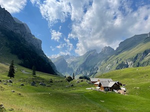
For the second part of our summer holiday, Jules and I headed off for a less-than-successful two day walking trip to Meglisalp near Saentis.
The day started alright with a long but easy train journey to Wasserauen. We set off in good weather and with spectacular views as we headed up the hill. We took the allegedly “easy” route via Klein- & gross- Hütten, and Schrennen, but unfortunately it was a bit too exposed for those of us with acrophobia. After struggling along the traverse for a bit (and some deliberation) we decided to abandon the trip and turn back. Instead, we went for a very pleasant walk around the Seealpsee and yours truly went for a bracing swim. We picked up some cheese from the farm at the head of the lake before looping back down to Wasserauen.
Overall our walk was 11.6km with 775m ascent / descent and took us 4 hrs 20, including the breaks and a swim. It's probably only a T2, but quite exposed along the traverse. The gpx plot of our route is here.
The worst part of the day was that I lost my Tilley sunhat somewhere along the route. I shouldn't be so upset (it's just a thing), but I've had that hat since walking in Turkey, and it's been a lot of places with me since then. Ho-hum, never-mind...
Walking Drei Gipfeli (three peaks) - July
For our first decent walk of the summer, Jules and I headed to Flumserberg to do the three peaks (drei Gipfeli) circular route from Maschgenkamm.
We last did this walk in July 2016, and we were very happy to head back. This time we started from Flumserberg Tannenbodenalp and took the Maschgenkamm gondola up to the start of the walk. We thought that we had arrived in good time, ready to head off on the walk at 10:45, but to our slight surprise the last ride down on the gondola was at 16:45, which only gave us 6 hours to complete the walk - almost exactly what it had taken us the last time. Note to self - next time aim to get to the top of the gondola before 10am to have a more relaxing day out!
Conditions were slightly less than ideal as we headed off - quite a stiff breeze along the ridge, and low visibility where we crossed the cloud base and were actually in the clouds. However, that made for a pleasantly atmospheric walk, and very few other people about. We made steady progress up around the ridge and then over the pretty green meadows on the plateau to the cross-roads point. We decided that we did have time to do the extra loop around Madseeli and to stop at the Spitzmeilenhütte for a coffee - very happy to give them some business, although we didn't have time to stop and eat.
The weather brightened up for the second half of the walk with plenty of sunny spells, which made the meadows on the plateau and the views back across the ridge very pretty indeed. The final section of the walk was fairly easy on good paths although there is a bit of a heartbreaker up to the gondola to finish. If we did this route again then I'd be tempted to extend the Madseeli loop up to the Wissmeilenpass, round the back of Spitzmeilen and down the Schönegg ridge (but I suspect I'd do that alone, and it looks a bit intimidating).
It felt a bit easier for me than last time, even though we were pressing on with relatively few breaks in order to make sure we could catch the last gondola. Overall it took us a pretty respectable 5 hours 10 minutes to complete the 17.8km with 890m of ascent/descent. We'd rate it a T2, and the gpx plot of our route is here.
Walking Albisgütli - May
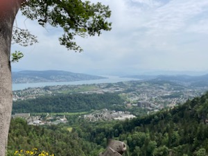
Wanting to get out for a brief stretch of the legs, but without travelling too far, Jules and I headed down to the Uetliberg / Albis ridge for a walk up and around the hill.
We didn't have a good plan, but just went to Albisgütli on the tram and then decided to make it up as we went. We started up the hill and then followed the ridge along away from the Uetliberg enjoying the views out over the Zurisee from the many look-out points.
We declined a stop at the tea hut (although it did look good on the way past), and instead dropped down to Leimbach and from there followed the Sihl back to Albisgütli
Overall it was 9.4km with 375m of ascent & descent, which took us 2 hours 10 at a fairly gentle pace. It was exactly what we were looking for - a nice stretch of the legs with a bit of a climb but without any travel or navigation stress. The gpx plot of our route is here.
Walking Thurgau Im Bluescht - May
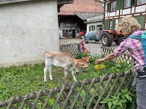
With a slightly overcast day forecast - not quite as sunny as we hoped - but mostly dry, and keen to get out, Jules and I headed over to Felben-Wellhausen to try walk #25 from Wanderungen in der Schweiz - Thurgau Im Bluescht.
We were a tiny bit late in spring to see the blossoms for which the walk & area are famous, but we did catch some late cherry blossoms, which were very pretty. The walk itself was a nice stretch of the legs through very fertile and productive farmland. We saw two very young calves - one had a bit of a suck on the fingers (cow slobber - lovely) - probably less than a week old and slightly nervous but inquisitive. We also saw lots of kites, a buzzard and maybe a kestrel, although it flew past very quickly.
It was a nice walk and a good stretch of the legs, which we'd consider doing again to time with the peak of the blossoms. It was 16.2km with 450m ascent and 300m of descent, and took us 3 hours 50 all in. The gpx plot of our route is here.
Walking Olten to Aarau - April
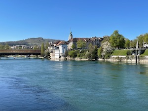
With a bright and sunny day forecast and keen to get out for a stretch of the legs, Jules and I headed to Olten to walk along the Aare to Aarau, hoping to meet Diana and Luis on the way.
It was a bit colder than we'd expected in the stiff breeze, but wrapped up warm we headed off following the Aare downstream. The river is quite wide at Olten, but divides after a couple of kilometers at the hydro-plant. We chose to follow the more gently flowing branch of the river below the plant through a very pretty protected nature reserve.We saw some evidence of beavers along the riverbanks as well as the usual river birds.
We made good progress following an Aareland Weg, with no navigational challenges at all. We stopped for a packed lunch on a bench by the river - there weren't too many options for food on Easter Sunday in this part of the world - and then continued on to Schönenwerd where we met up with Diana and Luis. We headed on together to finish the walk near Aarau, to complete a lovely, stress- & navigation-free day.
Overall it was about 16.1km, which took us 3 hours 35 including the stop for lunch.
Walking Bülach to Kaiserstuhl - March
With a lovely late spring/early summer day forecast, Jules and I headed up to Bülach to try a walk from the 2022/23 Zürcher Wanderwege. The weather certainly didn't disappoint - we were treated to bright blue skies and clear views all day.
The route heads out of Bülach through the town but then quickly diverts into the rolling hills and farmland of the Glatt valley. There are two minor climbs on the route, the first up to Strassberg and the second up to Hochwacht on the Stadlerberg where yours truly went up the lookout tower (Jules declined)
We had a picnic lunch slightly away from the crowds at Hochwacht and then continued to drop to the Rhine. The highlight of the trip was definitely seeing a beaver! It had made a few dams in a small stream leading out of Weiach and didn't seem particularly bothered by us as it went about its business. Lovely to see it, and it really made our day.
From there it was just a short stretch on to Kaiserstuhl on the Rhine and then the train back to town to complete a very pleasant spring walk. Overall it was 17.6km with 360m of ascent and 410m of descent that took us 4 hours 10 minutes (including the brief stop for lunch and the odd break) and we'd rate it a T1. The gpx plot of our route is here.
Walking Atzmännig - March
With decent weather forecast - warm enough for March and with sunny spells possible - Jules and I headed to Atzmännig to do the classic route around the horseshoe ridge.
It was much brighter and warmer than we expected when we arrived. The restaurant at the base was closed (which was a bit dull), but we headed off in good spirits. We were rewarded with fantastic views once we reached the ridgeline - the visibility was much better than we expected and the Alps were in full glory.
We didn't stop at restaurant Harz (we felt a bit guilty about that, but they seemed busy enough) and instead ate our picnic en-route. The walking conditions were mostly OK - a bit snowy underfoot but fine in boots. There was only one quite treacherous section - a traverse across deep snow on a steep section over a pretty nasty slide-then-drop-over-a-cliff that would have been lethal (don’t tell Jules - she’ll kill me) but we got past that without incident and the rest of the walk was fairly easy.
We finished the route in glorious sunshine, very happy to have made the trip out. Overall it was 9.4km, with 650m ascent & descent and took us 3 hours 30 (including the picnic and all the stops for photos. It was a T2 in those conditions, possibly even a T3 on the nasty traverse where real care was needed. The gpx plot of our route is here.
Skiing Flums - March
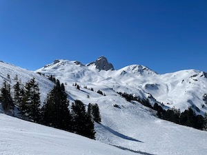
With another lovely Monday forecast, Steve and I headed to Flumserberg for a cruise around (mostly) on-piste.
There were hardly any queues when we arrived, and we bought our tickets very quickly and headed up the mountain. There was no fresh snow recently but conditions were still nice enough in the shaded and protected areas.
We spend the morning cruising around, and managed to cover most of the mountain including quite a few little off-piste areas. We had great fun in the gullies under Maschgenkamm - past the Maschgenlücke restaurant then hang skiers left before turning harder left and dropping down.
We stopped for lunch at the always good Seebenblick hotel, enjoying a seat in the bright sunshine. In the afternoon we cruised around a bit more - including coming down the front face of Leist to Grueb, which was good fun. We finished with a trip up the last lift to Leist (the chair was literally closed behind us), and looped round the back to Plattis and a cruise back from Maschgenkamm to finish.
It was a lovely day in good company - great weather and a good mixture of more and less challenging runs. Overall we managed a perfectly respectable 38.2km, and 7,300m descent over 27 runs.
Skiing Flims - February
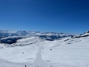
With a beautiful day forecast and keen to get to the mountains for a day of skiing, I twisted Steve's arm (it didn't take a lot of twisting, to be fair) and we headed off down to Flims/Laax for a day of cruising about.
The journey there was a bit dull owing to a traffic jam going into the Wallensee tunnel, however we arrived without incident and only a bit later than planned. I was a bit surprised at how expensive the lift ticket was - Fr. 95 (not including the deposit for the pass itself) and very long queues to get up the mountain, a theme that continued for most of the day.
Despite being slightly grumpy bear at the start, we quickly settled into the day. My technique was a little better than I feared, and fortunately I was just about able to keep up with Steve. We started on more gentle runs, but then got tempted onto the ski routes. As sometimes happens the snow was in better condition on the ski-routes than the hard packed pistes, and we had a good time in the lovely sunny weather.
We stopped for a short-ish lunch in the sun at Ruschein hut - below Lavadinas chair - for a good Gersten soup. In the afternoon we continued to cruise around taking the opportunity to get off the main pistes when we could. The best runs of the day were the ski-routes off the top of Lavadinas, particularly those in less sunny aspects. We finished with a run down Stretch, which was a bit busy and bumpy (not a great combination) but we got down safe to finish a very good day.
Overall we managed a pretty respectable 42.7km, and 7,800m descent over 15 runs. It certainly felt like a decent day when I tried to get out of the car...
Winter Walking Rigi - February
With a beautiful winter's day forecast and wanting to go to the mountains but not keen on a long drive, Jules and I headed over to Schwyz to try a winter walk on the Rigi, courtesy of Winterwanderung Schweiz 2021/22.
We took the train to Arth-Goldau, then changed to the ratchet & pinion railway for two stops before changing again to take the cable car up to the top at Rigi Scheidegg. Despite the changes it was a very smooth and easy journey with no stress - classic Swiss.
It was quieter than we expected up the mountain, and we enjoyed the spectacular views in relative peace and quiet. We made steady progress following on the snow-covered path as it winds around the peaks of the Rigi. We stopped for lunch at First in the restaurant Bärenstube - a perfectly acceptable goulash soup for me, and a fitness teller for Jules.
Suitably refreshed we pressed on a little further than the published walk and went all the way to Rigi Kulm. We missed the train down by seconds, but the nice people running the railway gave us a lift down in another train (one used for shuttling toboggans) so we had a private ride down the mountain!
It was a lovely day out, with beautiful views and a good stretch of the legs. Overall it was about 11km with about 400m ascent and 250m descent overall. It took us about 3 hrs 30 not including the stop for lunch.
Snowshoeing Biberegg - February
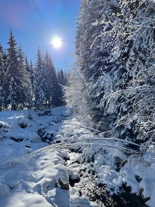
With a beautiful day forecast and keen to get out, Jules and I headed over to Biberegg to do snowshoeing route #815 from https://www.schweizmobil.ch
I managed to remember my boots this time, which made life a lot easier. We parked at Biberegg (they've started charging people not using the skilifts, but that's fair enough) and headed off in bright sunshine up the hill.
We took the ascent at a gentle pace and were rewarded with beautiful views from the top. The Rigi was in full view, and behind it Pilatus and the rest of the Alps stretching off to the distance. Behind us the Grosser- and Kleiner- Mythens were also in great view in splendid sunshine.
We headed down to Herrenboden for lunch, which was an excellent bowl of Gursten soup and chips. We also took away a hirsch wurst, which was quite good.
After lunch we declined the extra loop, and instead headed back down to Biberegg to finish off a lovely day out in beautiful weather and with good views.
Overall it was 10.3km with 600m of ascent / descent and took us about 3 hours 20 not including the stop for lunch. It's a WT1 and the gpx plot of our route is here.
Walking Meilen to Forch - February
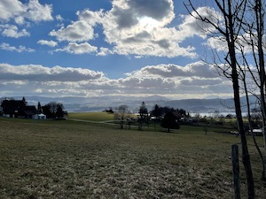
After a failed attempt to go snow shoeing - owing to forgotten boots, doh! I headed down to Meilen to walk up to Hochwacht and over to Forch.
It was a slightly later start than I planned but the weather had improved during the morning, and I was treated to sunshine on the way up the hill. The visibility was fairly good - I could see all the way to the Rigi & Pilatus, but there were clouds over the alps proper
It was slightly more chilly at the top (still February, after all) and I declined the walk up the tower, although I did go and find the technical high-point of the Pfännensteil. I decided to stop at Forch whilst still in the daylight, making the walk shorter than I have done in the past.
It was good to get out in lock-down, and this route is always a good stretch of the legs. Overall it was 10.7km, with 460m of ascent and 220m of descent and took me 2 hours 35 without really stopping. The gpx plot of my route is here.
Winter Walking Alt St. Johann - January
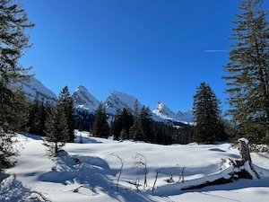
With a glorious day forecast, Jules and I headed over to Alt Sankt Johann to do a winter walk along the Sellamatt Sagenweg.
We weren't the only ones with the idea of getting out in the great weather. The carparks Alt Sankt Johann were completely full, and we were directed to park along the road heading out of the village. Much later and we'd have been parking in the next village and walking back! We shared a gondola up the mountain with Jackson the dog and his owners who assured us that he could run for longer than they could snow-shoe.
At Sellamatt we started out on the Sagenweg and followed this approximately. We must have done a variation on the walk because our total distance was less than the advertised walk, but it was still lovely to get out and to see the Churfirsten and Sattel in the glorious sunshine and under a layer of snow.
We stopped briefly for a cup of tea and chocolate brownies (courtesy of Andrea) at about the half-way point before making our way back to Sellamatt. We stopped for a light lunch at the bergrestaurant next to the top of the Gondola to finish off a good stretch of the legs with some lovely views.
Overall we walked for 8.5 km, with about 250 m of ascent/descent, which took us a bit more than 2 hours including the break. The gpx plot of our route is here.