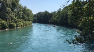
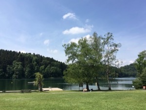
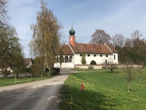
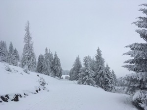
Visting Baden - December
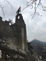
With a pretty rubbish day forecast, but keen to get out for a bit of a stretch of the legs, Jules and I headed to Baden to meet up wiht Diana and Louis for a bit of a stroll around and a bite of lunch.
We started out along the river, unfortunately having to take a detour owing to building works on the town side, and then followed the path out of town. At Infang we left the river and struck out uphill through the woods to loop back into tow via the castle. It was a pretty relaxed walk - more of a stretch of the legs rather than a proper outing.
Arriving in town we headed to the pub for a late lunch and a rather good pint of ale. Overall the walking was a shade under 10km. The second half (through the woods) was better than the riverside, but it was all fine.
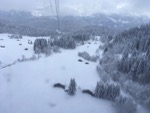
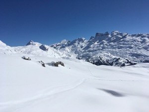
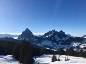
Skiing Engelberg - December
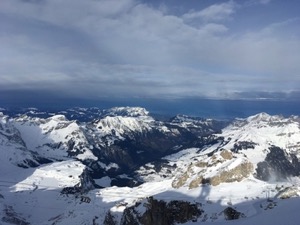
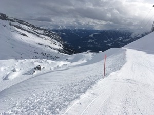
With the early-season skiing conditions continuing to be excellent, Michael and I headed over to Engelberg for a day trip during the Christmas break.
My last trip to this resort (with Andy in 2015) was a bit of a wash-out, with much of the mountain closed and the snow pretty marginal. This time however, Engelberg did not disappoint and we had a excellent day skiing on pretty empty runs.
We started with a run down #1 / Rotegg, which we did a couple of times - a great warmup and quite a rewarding run. We managed to ski most of the open pistes, and spent a bit of time under the Jochstock Xpress, on the not-yet-pisted run #11, trying to remember how to ski in slightly more technical re-frozen powder (it wasn't pretty).
Lunch was a rather good Roesti at the restaurant at Stand - recommended, but necessary to reserve a table in good weather.
Overall we managed a pretty respectable 35km and 7,500m descent. The 18/19 season starting rather well!
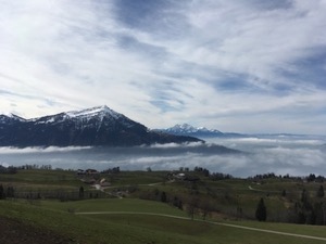
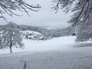
Skiing Flims - December
With an early season dump of snow, Michael and I headed to Flims to try to get our ski legs back in preparation for the 18/19 season.
The weather was a little better better than the forecast suggested and we had pretty good visibility for most of the day, with the exception of a low band of cloud between 1,800 and 2,000m. Unfortunately the top section of the mountain was closed, which was all in brilliant sunshine for most of the day!
In total we managed a pretty respectable 40km, with 7,000m of descent. A great start to the season...
Walking Watlikon to Egg - November
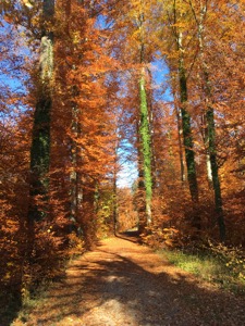
Feeling the desire to go for a gentle walk without too much preparation or travel, Jules and I headed to Watlikon to walk over the Pfannensteil to Egg.
The cloud and fog from the morning cleared up about lunchtime, and with the promise of a lovely autumn day we headed off. I took the opportunity to try out a new pair of walking shoes - lightweight walking in good weather / mid-season shoes and this looked like a good day to put them through their paces.
We took the train to Waltikon, and then followed tracks we know to Forch. From there we followed the well trodden route to Vorderguldenen, but then instead of heading over the Pfannensteil proper we turned to head down to Egg.
We were treated to lovely autumn colours on the trees, in particular the beech and maple were looking spectacular in browns and reds and it was a very pleasant walk.
In total it was slightly over 10km, and took us exactly 2 hours. There was 250m of ascent and 360m of descent, and the GPX plot of our route is here.
We finished with a cupcake and a coffee in Luus Muus in Egg before taking the train back to town to complete a lovely afternoon.
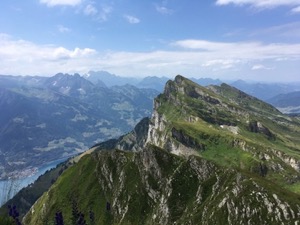
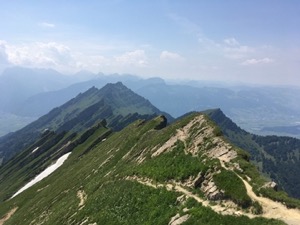
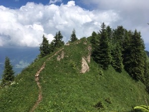
Walking Kronberg - October
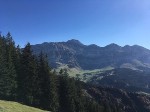
With an absolutely stunning late summer day forecast, Jules and I headed to Urnäsch to walk up Kronberg.
We took a slightly different route compared with my previous walk-up with Tom in May, this time following the Appenzeller Alpenweg (stage 2) route past Petersalp and up to above Kleinbetten before turning north to Kronberg. From there we declined the walk down, and instead took the Seilbahn back to Jacobsbad and then the train back to Urnäsch.
The route climbs fairly steadily for the first two thirds, and only really levels out near the end as it follows the ridges as it loops around and up to Kronberg. Jules was very brave on the ridges on the final section, which look bad from a distance, but which are OK once you're up close.
The views were absolutely spectacular, with great visibility along the alps. Säntis was in particularly good form, with autumn bronzes and reds on the upper slopes contrasting the stark rock formations on the peaks.
Overall the 9.5km with 1060m ascent and 300m descent took us a bit under 3 hours, and I'd rate it a T2. The GPX plot of our route is here.
Via Ferrata Pinut - October
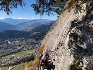
With a beautiful late summer day forecast, I took Jay up on his kind offer of a Via Ferrata trip up the historic Pinut route in Flims.
After a slightly stressful journey (unusual in Switzerland), and a bit of equipment faff, we headed off up from Fidaz to the bottom of the Klettersteig (Via Ferrata) route.
The route is the oldest surviving Klettersteig route in Switerland, was opened in 1907, although the metal work has been renovated since then!
The climbing sections are in three parts, with walking in between. There are lovely views across the Vorderrhein valley and the opposite hills and peaks. Although being graded a T4 (requires the used of safety equipment), the route feels very safe and well protected.
We stopped for a very welcome drink and relax at the small farmers hut at the top of the ascent, before heading down to Bargis for a well earned beer and a relax in the sun.
It's a T4 route (unwise without a safety harness), with about 1000m of ascent/descent and took us 3 hrs 35 minutes (not including lunch), at a fairly gentle pace, occasionally waiting for others to complete a section ahead of us.
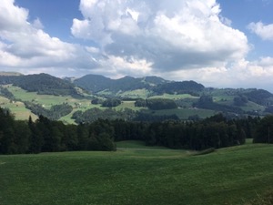
Walking Flumserberg - September
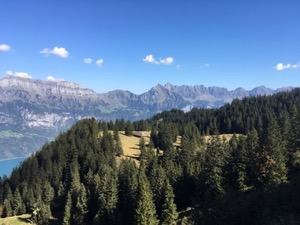
With the promise of lovely weather, finally perfect for Andreas and Inge to have a proper view of the Alps (sadly lacking in previous visits), we decided to head to Flumserberg to try the summer variation of one of our favourite winter walks.
We drove to Oberterzen and took the gondola up to Tannenbodenalp, which was a good call as carpark at the top completely full. After a prepartory coffee, we set off along the now familiar route, enjoying the views over the Walensee and the Churfisten, all in glorious sunshine and wonderful visibility.
We arrived in Seebenalp in time for a late lunch - very tasty and good service as usual, before deciding to do a lap of the Grosssee before heading back down the way we came.
This route remains one of our favourite walks with guests and visitors in good weather. It's very enjoyable, with specatcular views and not to strenuous.
Overall the route was 8.9km, with 380m ascent/descent which took us about 2 hours 15 of walking time. It's a T1, with very easy navigation. The GPX plot of the walk is here.
Walking Stans - September
With a good day forecast, and looking forward to the first walk in a little while, Jules and I headed over to Stans to try a route from Zuercher Wanderweg, #55 Am Stanserhorn.
We parked in Stans and headed up the hill, past the pretty market square and old Kloster then fairly quickly onto the ascent. The first part of the climb was fairly steady, benefitting from the cool of the woods and making height reasonably quickly. Higher up the slopes we were treated with views of the Rigi and the surrounding hills and peaks.
Having reached the top of the climb, the walk then followed the contours of the hill for the middle section of the walk. We stopped for a welcome drink and pleasant chat at the mid station for the Seilbahn before starting on the descent. On the way back into town we stopped briefly to pick up some new season apples from a Hofladen, before arriving back at the car, having had a good stretch of the legs.
Although this was quite a pleasant walk with decent views, I'm not sure we'll rush back to do it again. It's a bit hard work for anyone who's not used to decent walks in the mountains, so we're less likely to take guests or visitors. Also there are more spectactular walks around with less travelling. On the other hand, we were pleased to have done it, and to have seen some new views.
Overall the walk was 14.3km with 870m ascent/descent and took us 3 hours 40 minutes of walking time (plus the stop for lunch). It's a T2 owing to the fairly steep ascent through the trees in the first third. The GPX plot of our route is here.
Swimming Aare - August
Keen to try out the river swimming in the Aare, I headed off to Bern on a bright, sunny day to give it a go.
I'd previously bought a river (waterproof) bag, and suitably equipped drove to Bern for a day out. I decided to park in the centre of Bern and use the car as a bit of a base, which turned out to be a good idea. I packed up my swimming kit and headed down to Freibad Marzili to check it out.
There were a steady stream of people floating down the river, and getting out at Marzili, and suitably reassured that I was in the right place, I walked up to Eichholz to give it a go myself. The river was flowing surprisingly fast and it only took about 15 minutes to float all the way back down to Marzili, although it was great fun in the process. I did the same loop a second time, heading back to the entry at Eichholz and floating back to Marzili, but for the third attempt I decided to try something a little different. I walked all the way to Giessenhof, in an attempt to swim back all the way down, but was forced out of the river by the rapids below Bad Badanstalt. I managed to get back in a little past the rapids and from there was able to float all the way back to Marzili to finish a very fun day of swimming. Linked are the GPX plots of my first, second and final swims.
With a little time to spare, I headed in to see a bit of Bern, including stopping at the brewery at the Altes Tram depot to pick up a couple of bottles of the local beer, and a tour of the old town.
Walking Bachtel - August
With another hot day forecast, and keen to get out without driving too far, Jules and I headed to Wald to walk up the Bachtel.
It was pretty hot going in the sun for the first part of the walk, but we quickly moved up into the breeze and some shade where the temperature was much more pleasant. As usual this walk turned out to be much longer and higher than I thought - it's actually over 500m of ascent, although the views at the top are well worth it.
We arrived at the Restaurant Bachtel Kulm in the early afternoon and found some perfect comfy chairs overlooking the Zurisee, with views of Gross Aubrig in the distance. After a bit of refreshment we headed on, taking a slightly different route back via Hueb and Dieterswil.
Overall the walk was 9.8km with 530m of ascent/descent and took us 2 hrs 20 plus the stop for a drink. The GPX plot of our route is here.
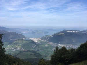
Walking Gross Aubrig - August
Keen to checkout the Wägitalersee area, I went down to Innerthal to try route 29 from Rund um der Zurisee, a walk up the Gross Aubrig.
I've wondered a few times about a very distinctive rounded peak that's visible from the area around Rüti, and suspecting that it was in the area, I headed down to Innerthal to find out. I decided to try the slightly less technical ascent of Gross Aubrig (rather than Bochmattli or Brünnelistock or Fluebrig) on this trip, and instead to do some scouting around for a future trip as well. This turned out to be a good plan, as there were quite a few roadworks going on around the lake, and travel isn't trivial to all the villages where the routes start. However there was no difficultly with the ascent of Gross Aubrig, and after parking up at Innerthal I headed off.
It's a fairly straightforward linear route, with no real variations possible. The route up is fairly steep in lots of parts, and on slightly slippery loose soil and rocks - probably a result of the recent baking heat & walkers. A good fraction of the first part of the climb is in trees, but these thin out past Bärlaui, and from there it's broken cover for the remainder of the route. There are good views east, south and west en route, the general shape of the mountain being a half dome. There are pretty sheer drops right at the top (protected by a barbed wire fence), but it's not very intimidating as there's nowhere you're forced to go to the edge. From the peak at 1695m there are wonderful views out over Siebnen and a good fraction of the Zurisee. The way back down was a bit slower than I expected - the very loose ground making for careful going and a couple of slips (although no falls).
Overall it was just over 10km and 800m ascent/descent which took about 3hrs 40 all in (slightly over 3 hours walking). It's a T2 with no particuarly tricky areas, although right at the edge of the top is a bit sheer, and the conditions could make it easy to slip on quite a few parts of the path. The GPX plot of my route is here, along with the slight navigational error caused by cow and cowherd distraction (don't get between a cow and its shed!)
Walking Amden - August
With a very hot day forecast, Jules and I decided to escape the heat by going into the mountains, and to try a high route, with not too much climbing. We agreed to have a crack at a route around the base of Mattstogg, which was a variation of the Speer climb that I did in July.
We took the chairlift up from Amden to save the hot slog up to Niederschlag, and then walked along the track to Strichboden for a bite of lunch (complete with Swiss National Day singing), before heading off proper.
The plan basically paid off with a nice cool breeze and a much more pleasant temperature up at 1,200m, and we had a good walk around to Hinter Höhi. From there we continued on round the base of Mattstogg and then climbed slightly to Oberchäsere, where we stopped for a drink. Suitably refreshed we then looped back to Amden, taking the signed paths and roads to complete a good day out.
This is a fairly good medium-effort route, without too much travel from Zurich and with the option to do a bit more (including obviously ascending Speer). In good visibility the views are very good, including Säntis and the Churfirsten, plus the Walensee and down the Glarus valley. Definitely one to keep in mind for the future.
Overall it was 12.75km with 436m/807m ascent/descent and we'd rate it a T1. The GPX plot is available here.
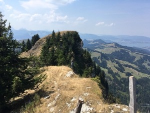
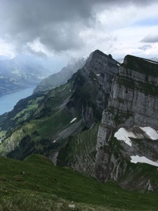
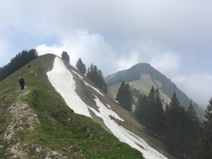
Walking Selun - July
With a beautiful day forecast - good visibility and bright and sunny I decided it was the perfect day to climb Selun, the westerly-most of the Churfirsten.
The tiny Seilbahn Selun was running at Starkenbach, and I decided to take this for the novelty (plus also avoiding the first part of the climb out of the valley in 30+°C). Selun is visible From the top of the Seilbahn, and typically well signed, with basically only one junction. I made fairly good progress up the hill, stopping after an hour, about 5 minutes from the top for lunch and a drink of water. I think the rest stop was well placed, as it meant the I was recovered by the time I reached the top which helped slightly with the sheerness and typical lack of any protection at the top. After a couple of photographs I started back down, and elected to walk all the way back to the valley. This adding a couple of thousand feet to the descent, mostly on steep paths and tracks through the woods.
It's a good fun climb, wiht very impressive views at the top. As usual, I'd only attempt it in fairly good weather. Overall it was 8,4km with 620m / 1300m ascent/descent and I'd rate it a T2. The GPX plot of my route is here.
Walking Speer - July
With beautiful weather forecast, and perfect conditions to walk up a slightly more technical hill, I headed to Amden to walk up Speer.
I was following route # 21 from Rund um der Zurisee, and the book certainly didn't disappoint. After the last couple of walks turned out to be a bit tasty, I was quite grateful for the basically circular route, with just a spur up to the top of Speer and back down again.
The start of the route was a bit of a slog out of Amden, mildly irritated by the horse flies - next time I'd be tempted to take the chairlift up and avoid this bit of the climb. From Niederschlag the route follows a well made gravel track around the side of Mattstogg before turning off onto a smaller (but easy to navigate path) to Oberchäsere. From there the ascent of Speer is quite obvious, albeit a bit of a climb. The only intimidating part is the last 5-10 yards, before ascending the metal stairs to the (secured) viewing platform at the peak. From the peak it's the same route back down to the Oberchäsere hut, and from there the route loops east around the end of the Walenstein, passing through Durshlegi on the way back to Amden.
Overall it was 17.2km, with 1130m ascent/descent and spectacular views. I'd rate it a T2, and the GPX plot is here.
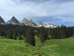
Walking Planggenstock / Hirzli - June
With the weather a little better than forecast, I decided to head out for walk at slightly short notice. The chosen route was #22 from "Rund am der Zürichsee" by Rother - Planggenstock & Hirzli.
After a slightly delayed start, I arrived at Niederurnen just missing the last lift of the morning. I decided to walk up to Morgenholz rather than wait for the first afternoon lift, which was a good warmer-upperer, but quite steep and hot work. The route then progressed along the valley before turning right and starting to climb up the side of the valley. The final ascent to the peak at Plaggenstock wasn't for the faint-hearted, nor was the route along the ridge line to Hirzli - I now know what "Nur für schwindelfreie berggänger" means! I arrived safe but slightly more nervous at the top of Hirzli, where I was rewarded by great views along the Walensee and also of the Churfirsten and the Glarnisch group. From there it was a steep but non-technical descent back down to Morgenholz, where I arrived just in time to take the mini-Seilbahn down the hill.
Overall it was 10.3 km, including 1280 m ascent / 750 m descent, and I'd rate it a T3, but only because of the exposed sections on the ridge, two of which were protected by wires. Overall it took me about 3 hours, and the GPX plot of my route is here.
Walking Chaeserrugg / Hinderrugg - June
With great weather forecast, I headed over to Alt St. Johann with the intention of walking up Selun. After a brief change of plan caused by parking logistics, I actually set off up Hinderrugg and Chaeserugg (a certain flexibility can be a good thing).
I had great weather all the way up to Sellamatt and then most of the way up Hinderrugg, just a few spots of rain on reaching the top. There are very spectacular (and slightly scary) views from the col between Scheibenstoll and Hinderrugg, and looking eastwards along the Churfirsten. The path up the final ascent of Hinderrugg was a little intimidating, as the fall line down the steep, wet grass slope actually goes off the cliff onthe Walensee (south) side of the Churfirsten. Needless to say, I was taking some care on that section!
I stopped briefly at Chaeserrugg for lunch before heading back down the “Athletes Way” to Sellamatt and on back down to Alt St Johann. Weather pretty good for most of the day - mostly sunny with just a few clouds and spots of rain at times.
Overall the walk was 15.7km, with 1500m ascent/descent. It took me 4 hrs 30 walking, plus about a 30 minute lunch break, and the GPX plot of my route is here.
Visiting the Thurlersee - June
With a lovely morning forecast, I decided to cycle over the Albis pass to the ThurlerSee for a relaxing swim and sit in the sun, with a loop back home round the end of the Uetliberg.
It was slightly hot conditions for the ride probably over 30°C in the sun, and a bit of an effort to get over the Albis pass. Once at the top it was a very pleasant and easy run down to the Thurlersee to the badi. It was much less busy than on a weekend and a very pleasant place to lie and relax with an occassional swim in the lake to cool down.
After a quick bite to eat I headed off to complete the loop back to town, to finish a very nice, chilled out day. Overall I was cycling for a little over 2 hrs, and it was just over 45km in total.
Walking Sellamatt Sagenweg - May
With a beautiful day forecast and keen to get out, Jules and I headed to Sellamatt to try a walk that we found in www.outdooractive.com. We drove to Alt St. Johann and took the cable car up to Sellamatt and then headed off, following the locally signed "Sagenweg", stopping occassionally to look at the picture boards. The spring flowers were on good form, as the route winds along alpine meadows with the jagged peaks of the Churfusten (still with some snow patches) in the background and Fantastic views of Säntis across the valley.
We made it as far as the Wildinannli hutte, which unfortunately was closed, but we ate a light packed lunch on the benches and declined the extra small section heading up towards Selun. We returned following the Sagenweg, but decided to make a slight detour to make the route a bit more interesting.
All in all a lovely day out walking - fairly gentle but picturesque and lovely in spring, with the flowers and even a Cuckoo out of sight in the trees.
Overall the 11.9km with 220m ascent/descent took us 2hrs 45 and we'd rate it a T1. The GPX plot of our route is here.
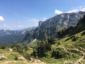
Walking Creux du Van - May
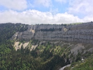
Many thanks to Diana & Luis for suggesting and organising an excellent walk in Neuchatel, the locally famous Creus du Van.
It was a bit of a trek from Zurich, but with fairly convenient trains we arrived late morning and after re-victualling at the little shop at the station we headed off up the hill.
It was obviously a popular route, and with a good day forecast it was fairly busy and we were walking single file with other groups on the ascent. It's been a while since we've done this kind of walking and we're obviously not used to it any more! The route up was fine, we chose to do the steep ascent and more gentle descent, which was probably a good call since the path was a bit muddy and quite slippery underfoot.
Arriving at the top we were rewarded with spectacular views around the amphitheater - it's easy to see why this is such a popular destination. It's reasonably safe at the top, although not great for anyone with vertigo or acrophobia. It's easy to stay away from the edge, but in typical Swiss fashion there are no railings or barriers - common sense is expected to provide all the protection one should need!
We walked a short way around the amphitheatre and then stopped for a picnic lunch - Diana and Luis providing some lovely treats from their visit to an Italian market. We then continued on around the loop before dropping down to retrace our steps back into Noiraigue. Feeling very content we picked up some (excellent) local beers for the train ride back to town.
Overall the 13.7km with 790m ascent/descent took us 3hrs 25, plus a stop for a picnic in the sun and a coffee at La Grand Vy. It's probably a T2, and the plot of our route is here
Walking Kronberg - May
With a fairly good day forecast, but still to early in the year to go walking in the mountains proper, Tom and I set off to try route #12 from Zuercher Hausberg: Kronberg.
It was slightly cloudy at the start, but we were actually grateful of the cover as the route climbs pretty steadily out of Jakobsbad, past Lauftegg and up to Hoch. We made steady progress round to Kronberg, with the cloud clearing and the occasional glimpses of Säntis and blue sky.
We stopped for a fairly brief but perfectly decent lunch at Kronberg bergstation, then headed past a perfect paraglider launch point and made our way on down to Jakobsbad in glorious sunshine.
The route was rated T2+ and there were a couple of sections where it was a bit more exposed than a normal T2, however these were either fenced-off, or were more steep than actually a hazard. Overall it was a good route and it would be great to do it again in better weather, with the full views.
Overall the 15.2km with 975m ascent/descent took us 3 hrs 50. The GPX plot of our route is here.
Walking Frauenfeld to Wil - April
With a nice day forecast, but still too early in the year to go walking in the mountains, Jules and I headed off to Frauenfeld to try a linear walk to Wil.
The chosen route was from gps-tracks.com, although this is actually the Murgweg, and follows the path of the river from Frauenfeld to Wil, with occassional slight detours. The route itself was very easy to follow, with (typically) well made paths and plenty of signs.
We made pretty steady progress to Wängi, and stopped for a perfectly acceptable lunch at Restaurant Landhaus Rosental (which is in Rosental, rather than Wängi!), before heading on to Wil.
Overall the 20.8km with 420m of ascent and 250m of descent took us 3 hrs 55 minutes, and we'd rate it an easy T1. The GPS plot of our route is here.
Walking Zugerberg - March
With a slightly mixed day forecast, but keen to get out, Jules and I headed to Zugerberg to try a route with good views, but not too far to travel.
We arrived a little late in the morning, and had to find some alternative parking - the carpark at the bottom of the funicular being full. Once up the hill we set off in the direction of Wildspitz, but without really intending to get there - given the time of day, the day of the year, and a forecast of rain in the early evening.
We did make it as far as Alpli, where we discovered that the restaurant was closed for the mid-season, so we headed back to the Gasthaus Pfaffenboden for a perfectly acceptable late lunch. The weather was kind to us all day, and the views of the Rigi and Pilatus were quite impressive in the clear air, the valleys being filled with low cloud which really enhanced the effect.
All in all the 16.6km took us 3 hrs 25 (not including lunch) with 460m of ascent/descent. The GPX plot of our route is here.
Snowshoeing Melchsee-Frutt - March
With a glorious day forecast, and keen to make the most of it, I headed over to Obwalden to Melchsee-Frutt to try some of the local snowshoeing routes.
I decided to do a bit of a variation on the published routes, taking the black route 004 from Melchsee-Frutt to Tannalp, then the red 002 back along the other side of the Tannensee, then the 001 to the top of the Erzegg lift before doubling back to the 002 and following that down to Melchsee-Frutt. I think this was a pretty good choice as it takes in all the interesting (and in some cases more technical) parts of the routes, but avoids the long flat walk back along the bottom of the valley. The only difficult parts of the route were on the black section (no great surprise there) - a very slightly intimidating traverse just past Bonistock, and a slightly technical but very short descent off the ridge before heading down to Tannalp.
It was a fairly exerting day, and if I were to do it again in snowshoes then I'd probably take a little more time over the ascents, and overall try to go a little slower. It would make for a perfectly doable summer walk though, with lovely views of the surrounding mountains in the right weather.
Overall the 10.6km with 610m ascent/descent took me a little over 3 hours, plus a brief stop for lunch, and lots of stops for photos. The GPX plot for the route is here.
Skiing Flims - March
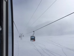
With some recent snowfall and trying to make the most of the season, I headed down to Flims to go skiing for the day wiht Jay and Izzy.
The conditions were a bit marginal for most of the day - decent snow, but low cloud making the visibilty quite poor. We pottered around for a bit in the morning before retiring for an early lunch in restaurant Stalla (just about managing to find it in the cloud!). After an excellent lunch of Kaese Spaetzli we headed back out to try the Laax side, but found conditions to be not much better. Not giving up hope we headed up to try the Glacier (and do a loop of the mountain), and found some excellent powder, in an island of sunshine just under Furcola lift. We skied the powder until they closed the lifts on us, and then headed back down a very foggy run #40 - possibly the slowest run of the season, skiing pole to pole all the way down.
Overall it was a pretty respectable day, we covered 40.9km overall, with 6,600m vertically.
Snowshoeing Mostelberg - February
Despite the cold forecast, and keen to get out, Jules and I wrapped up warm and headed off to Mostelberg above Sattel to go snow-shoeing above the Agaerisee.
The was a bitter wind and we pretty quickly changed in the warmer clothes we'd brought before heading off on the first circular snow-shoeing trail. The route started with the Skybridge, where Jules was very brave, but after that continued steadily around the side of the hill. There was a bit of a climb - probably about 45 minutes - to reach the top at Spillmettlen, and from there a short descent to reach Herrenboden. We had a rather good lunch in the berghaus Herrenboden, good service despite being full to the seams. After lunch we elected to do the winter walking route #1, which was a nice route, although we had to take off our snowshoes at one point to walk along a tarmac road just past Mostelegg.
All in all it was an excellent walk, albeit not quite at its best owing to the low cloud obscuring the views of the nearby mountains. We agreed that we must go back in better weather, and that this would make a good summer walk too...
In total for the day we managed a total of 12.1km, including 550m of ascent descent in 3 hrs 10. The GPX plot of our route is here.
Walking Kollbrunn - February
With fairly uninspiring weather forecast, - low, grey cloud - but keen to get out, Jules and I decided to try one of the lower altitude options in Rund um den Zuerichsee #9.
The route starts from Kollbrunn and climbs steadily before following streams and valleys as it winds in a large loop. We decided to do a variation on the walk, and to cut off one segment, but make it circular, which worked quite well.
The landscape was very pretty in the recent snowfall, although we were occassionally attacked from above by the snow falling off the branches and down the backs of our necks.
All in all it was a very pretty walk, and probably the best we could have made of the day. It would be good to go back in summer and do the official route, either extending the walk back, or catching the train from Raemismuehli-Zell to Kollbrunn.
In total, it was almost exactly 16km , and took us 3hrs 20, not including the stop for a (rather well received) hot gemuse bullion from the vending machine at the station.
Walking Forch - Meilen January
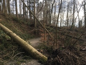
With the girls off at a horse show, my father and I headed over to Forch to walk down to Meilen for a bit of a stretch of the legs, and also to see the local woods.
We set off at a fairly gentle pace, taking the time to look at the local workings in the woods. We guessed that there had been a fairly major campaign going on to bring down larger trees for high grade timber, but that the recent storms had resulted in a lot more trees down that then needed tending to. We stopped at the Pfannensteil restaurant for a soup and Alper Macaroni (quite a full on meal!) before heading down via the stream to Meilen. We were both surprised by the amount of devastation on the last section - whole sections of the path had trees down and the clean up work was clearly going to take some time.
Overall the 10.8km with 240m ascent / 520m descent took us 2 hours 25, not including lunch. The GPX plot for our route is here.
Snowshoeing Brunni - January
With an excellent day forecast., and keen to get out and be sociable, Jules &. I headed to meet up with Diana & Luis, plus Carlos and family for a day snowshoeing.
After getting the boys kitted out with skis and the usual equipment faff we headed on up to Furggelenstock at a leisurely pace. The views were spectacular - the Grosse & Kleine Mythen we're framed in sunshine and the Rigi and further peaks were visible, with the valleys shrouded in mist.
The route up was slightly disrupted by the recent storms - we had to detour around some fallen trees, but otherwise the ascent was fairly easy on well packed snow.
We made very gentle progress (often distracted by the views), and arrived at the Furggelenstock hut at about 2:30, in time for a late soup lunch. From there we headed back down the way we'd come.
Overall the 4.8km took us 2 hours (not including breaks and lunch), with an ascent/descent of 460m in total. The GPX plot of our route is here.
Skiing Flims - January
Keen to get in a good start to the season, Jules and I headed to Flims to make the most of the good, early, snow.
I started off with a good blast on Stretch, which was empty as usual first thing, but a bit refrozen in places. From there I headed over to Sogn Martin to try to get to Vorab, which unfortunately was closed owing to wind, so instead did couple of loops of Scansinas on run #16 (which was excellent), before dropping down via Grauberg and run #10 via Startgels to meet Jules for lunch in Flims.
We declined the queue at the burger van at Flims - moving at Swiss speeds - and instead had lunch at The Cock Inn, an acceptable wurst and pretty mediocre burger. Next time we resolved just to go to the bakery in town which looks good and well frequented.
After lunch I headed up to towards the glacier, with an extra run down the Tres Palais, and the worlds slowest bubble up from Fuorcola. Unfortunately the drag lifts up the glacier were shut because of the wind and the conditions were pretty bad with strong winds blowing ice into your face. I headed back via other side of the slow bubble then did a loop round Plaun/Crap Sogn Gion, Plaun, Scanscinas and Startgels to finish the day. The light was getting a bit flat by the end, which made run #14 a bit tasty.