Alpen Panorama Route #4 (Rapperswil to Lausanne) - September
With a few days spare, and good weather forecast I decided to head out to see a bit more of Switzerland by bicycle. The chosen route was the Alpen Panorama Route, national route #4, which I started in Rapperswil and followed all the way to Agile and then onto Lausanne. The route I intended to follow is here, and I kept broadly to it, and was quite happy with it. Overall it was four fairly hard days of cycling, but with lovely views and a chance to see some more of Switzerland.
Saturday
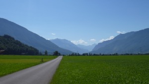
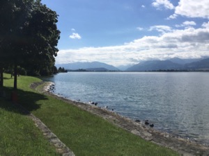
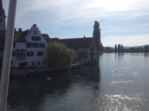
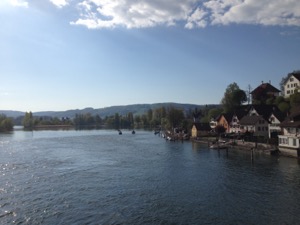
After a slightly later than planned start I headed off from Rapperswil at about 11am, under clear blue skies and with lovely views over the mountains. The route started well - basically flat and easy to Glarus. The climb up to Klöntalersee was a bit hard work in the 35 degree heat, but slow and steady won that particular race. I stopped for a perfectly acceptable lunch at Vorauen Am Klöntalersee, but probably should have carried on to the next (and last) gasthaus which looked very pleasant. From there it was a steady and slow climb up to Pragelpass - it was very hot and I was barely carrying enough water. There were beautiful views all the way up the pass, and particularly special at the top - meandering through alpine hill tops framed by mountains, with flowers in bloom. Pretty fast descent through Muotathal, and I decided to cut the day a bit short and ended in Schwyz. I was slightly surprised and a bit disappointed to have real trouble finding a room - two of the hotels I tried were completely booked and the last hotel in town only had a bunk in a shared room. Unfortunately I was travelling very light and was somewhat caught out without a towel or soap and had to get a bit creative. A couple of beers in the evening definitely helped restore a sense of humor, and I studiously ignored the hen do in the bar. All in all an interesting first day to start the trip. The GPX plot of my day is here and all in it was about 80km with 1,400m of climbing - mostly over Pragelpass - and took me about 7 hours.
Sunday
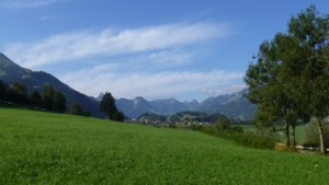
I woke feeling not quite 100% - probably as a result of not eating enough the previous day, but set off after a quick breakfast in Schwyz. It was another hot day, but a pleasant start to the route with a tailwind helped immensely. I was lucky and caught a convenient ferry at Gersau - turns out they only go once an hour, and there wasn't much to do at the terminal. I then continued on through Beckenried, Stans, Alpnachstad. I stopped in Giswil at Restaurant Siesta for a very good pork chop for lunch - a pleasant surprise. The main event of the day was the climb up to Sörenburg, which was about 1050 m to the peak. The weather was a bit kinder today - it clouded over as I started, and then with perfect timing cleared on the descent. Overall it was a bit of a slog. I was particularly grateful for the water fountain at about 1,200m elevation, and really need to get another bottle if I'm going to do stuff like this. The ascent took the best part of 3 hours, by which time I had an achy backside (to my slight surprise) and basically finished me. I took the shorter version of route 4, which degenerated into a rough track over a field (I was quite grateful for the Tout-Terrain at that point). To my surprise the hotel Kemmeriboden-bad had a room for the night, so I stopped there instead of carrying on to Thun. Dinner at the hotel was a rather good Zander fillet, in the lovely outdoor restaurant as the sun went down. A bit of a contrast to the previous night! The GPX plot of the day is here and it was about 90km with 1,750m of climbing and took me about 8 hours.
Monday
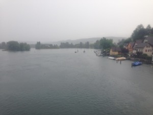
After a good breakfast at the hotel I headed off to Thun. The weather wasn't so good on this day - grey & overcast with rain showers and low cloud obstructing the views. With hindsight I was quite grateful that the Kemmeriboden-bad had a room the previous night, because it was another two hours to Thun, about 40km and 400m of climbing which wouldn't have been much fun the previous night. I arrived Thun in time for a quick brunch and a look around, but only saw the nice parts cycling out afterwards! It was a steady day of cycling through rolling hills in slightly sub-optimal conditions. I arrived Bulle in good time, and after establishing that the Hotel de Ville wasn't in fact a hotel, I decided to try that new-fangled internet thingy. I ended up in the perfectly functional Ibis on the edge of town which was just fine (but not quite the same as the Kemmeriboden-bad!). The GPX plot of the day is here and overall it was 125km with 2,000m of climbing spread throughout the day and took me a little over 8 hours.
Tuesday
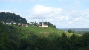
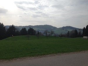
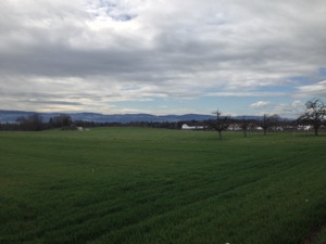
The start of the day was very relaxed as I followed the route out through very pretty villages towards the bottom of the Gruyères valley. I started the (last) climb at about 10:30, and stopped for coffee at the rather nice looking Hotel de la Croix de Fer. From there things went a little downhill, starting with a puncture about 500m down the road. I used my only spare inner-tube (oops), to discover that my pump wasn't working quite as well as I expected and wouldn't fully pressurise the tyre. I spent the rest of the day worrying about the tyre going flat, which wasn't very much fun! Reaching the top of the ascent, I was stopped by the Army who informed me that the road was closed until 6pm for military exercises which closed the route down to Agile. My slight sense of humor failure alleviated by two dogs (one a puppy) for whom a cyclist was literally the most exciting and cuddle-able thing they'd ever seen. After a drink and something to eat and consulting a map, I found an alternate route down on the fast but busy road #9, which would have been great if I hadn't been paranoid about my back tyre. I arrived Agile at about 14:20 to finish route #4. I had a sandwich and made the bad call to cycle to Lausanne, which turned out to be significantly further than I expected, combined with a strong wind in my face and inadequately signed route meant that I ended up cruising along the main road just to get to Lausanne. I arrived at 18:15 pretty tired and not having eaten enough since lunch time - I'll need to watch that in future. The GPX plot of the day is here and overall it was about 100km, with 1,500m of climbing and took me a little over 8 hours.
Overall, I was perhaps a bit optimistic about how much distance I could cover comfortably in a day. I think that the combination of large-ish climbs in combination with the distance (averaging 1,500m climbing and slightly over 100km a day) was tougher than I expected and is probably about the limit of what I'd try to achieve in the future. I think it was compounded by fairly heavy equipment and in 35 degree heat. I found the climbs quite hard, and it's notable that the day with the most ascent was also the easiest - probably because the climbs were small and spread out.
Winterthur / Rhein Circular - August
Fully recovered from our epic journey around Lake Constance, Jules and I decided to head out for a day-ride from Winterthur, taking in the Rhein and looping back through the pretty villages of Weinland.
The chosen route was #8 "Töss-Rhein-Tour" from Veloland Zürich, which turned out to be a very pleasant 57km circular route from Winterthur and following the Swiss cycle-routes 53, 2, & 86. We stopped in Ellikon am Rhein for a very pleasant lunch at the Gasthaus Schiff where we sat in the sun and watched the rope ferry travel backwards and forwards across the river. The weather was fairly kind to us with only one rain shower early in the route, although there was a bit of a headwind at times. The route has quite impressive views of the rolling hills of the Weinland interspersed with valleys and rivers.
Overall the 57 km took us about 3 hours of pedalling, with just the one stop for lunch. The GPX plot of our route is here.
VC Kaisten 150km - July
With a sunny day forecast, and being left to my own devices for the weekend, I decided to head up to Schwarzwald to try the VC Kaisten 150km circular route. The route starts in Switzerland, but crosses into Germany at Koblenz and from there loops around Gurtweil, Birkendorf, Bonndorf, Schluchsee, St. Blasien, Mutterslehen, Lindau, Hottingen, and Hänner before crossing back into Switzerland at Laufenberg.
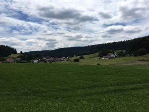
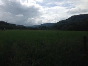
The route itself is very pleasant and quite varied, from high sided valleys in the first third, through the rolling hills of the Schwarzwald, with fun (sometimes a bit marginal) descents at Ebnet and Aeule, with some good views and some quiet woodland cycling. I found it a bit tougher than I expected - possibly I was going a bit quickly at the start, or maybe just the result of a long, hard week at work and not enough sleep. Anyway, about half way through I stopped worrying about my overall time, slowed down and tried to actually enjoy the ride, which was definitely the right thing to do! Equipment wise, the Garmin 520 did really well. I did a much more precise plot of the route this time, which meant that I didn't get as many "off course" messages, plus I disabled those warnings, and had picked a map screen with the details that I was most interested in seeing. I'm very pleased with it, and I actually cycled without any printed notes (although this did make me a bit nervous occasionally). The proof for me was that I didn't once need to take out my phone to check that I was in the right place.
Overall the 142km with 2,000m ascent/descent took me 6 hours 20 all in, and of that about 6 hours pedalling. It was a bit hard work at times, and I reckon this is about the limit of what I'm currently able to enjoy without much preparation. A couple fewer whiskeys the night before and going to bed a couple of hours earlier would probably have helped, for example! The GPX plot of my route is here.
Sattelegg, Etzel - July
For a bit of a change of pace, I headed out of Zurich to do a Tom's recommended route of Sattelegg and Etzel.
I decided to cycle there, and to take the the slightly longer route out of town via Rapperswil (because the route is a bit nicer along the #66 despite the head-wind on the day), then over the bridge to Pfaeffikon and then to do the circular section. This was the first route out with the new Garmin 520, which did alright, but was slightly handicapped by my plotting the route only very roughly (so the navigation kept getting confused because the road was too far off the course). I think in future more care plotting the route, and also picking a better route, is likely to be beneficial. The route itself was very pleasant - I followed the #76 on the slightly quieter road up the valley before joining Satteleggstrasse for the main climb. The descent from Sattelegg was great fun in perfect conditions, and the route to and final climb around the Etzel (on the #9) was also fine. From there the descent to the lake was also good fun, followed by a blast back into town - again into a head wind, how does that work?
All in all it was about 110km with 1,300m ascent/descent and I was pedalling for about 4 hrs 45. It's a really nice route, with good climbs, but not so steep as to be unpleasant. My notes for the route are here, and I'd happily do it again. Without the headwinds.
Round Canton Zurich - June
Waking up a bit late (feeling someone worse for wear), with achy legs and bad weather forecast, I decided that it was the perfect day to try the cycle ride around the whole of canton Zurich.
I started out from Rapperswil a bit later than hoped, but quickly got into the swing of it, remembering the route pretty well from the practice stages. Things were going well until Stammheim when the heavens opened (rain I can take, but the hail was a bit much), which soaked me and took most of the oil off my chain - I came to regret that over the next 100km or so. From there the ride continued pretty uneventfully, although the section Bremgarten to Zug- which I normally enjoy - dragged on a bit. Reaching Zug I decided that I did have the energy for the last leg, and set off for Rapperswil. I arrived back at the station 11hrs 45 minutes after I started, and I reckon that I was pedalling for about 11 hours of that.
All in all I reckon it was 250km and about 2,500m vertical ascent/descent, although I don't have the GPS plot or the accurate statistics because my phone battery gave up in Zug. Looking back I reckon that the first 8-9 hours were alright and good fun, but the last quarter was a bit of a slog. I might try to do rides of shorter duration in the future.
Horgen Meilen Circular - June
With a mixed weather forecast, but keen to get out and cycle, Jules and I headed off for a half-circuit around the Zurisee - cutting off the bottom section by taking the ferry from Horgen to Meilen.
We started out a little later than usual, having been up for Andrea's birthday party the night before. However, suitably fortified with tea and breakfast we headed off. The route started out along the Sihl, pleasantly off-road and not too busy given the less than ideal weather. We followed the long distance route #94 until Gattikon, where we stopped in a very pleasant café for a brioche and coffee. Refreshed, we continued over the hill (the only one of the day) and joined the #34 for a while before dropping down steeply into Horgen. The section along the side of the motorway wasn't as tranquil or picturesque as some of the routes that we've done, but it was a completely separate road and quite safe for the short time we were on it. From Horgen we took the very convenient ferry (6 CHF for two people plus bikes - a bargain!) to Meilen and then headed back into town on the #66. It was raining fairly steadily for the last leg, which was a useful lesson for our upcoming cycling holiday - even 30 minutes of steady rain and you're soaked on a bicycle.
Overall it was a pretty short and gentle ride - about 25 miles (40km) and it took us about 2 hours (plus breaks and lunch). The ferry was surprisingly easy, and the route over the ridge from Gattikon to Horgen was not particularly long or steep.
Cycling Limmattal - May
With the weather forecast as terrible, but keen to get out for a ride, we headed off to try a variation on route #2 from the Veloland Zurich book - Limmattal.
The route itself was pretty good, on well signed paths and mostly off-road. The main bit of excitement was yours truly losing a fight with a tram-line near the start but after a bit of a sit down and re-assurance that nothing was broken we carried on. It was raining for most of the journey, which made it a bit less enjoyable and the views a little less good than the route would otherwise have been. We did stop in Wurenlos for a much appreciated hot meal, and again in Kloster Fahr for a hot drink, both of which were very pleasant.
Overall the 34 miles took us 3hrs 40 minutes - at a very relaxed pace - and was virtually flat at 1,400ft VG/L
Cycling Stammheim to Rapperswil - May
The next stage in my preparation for the round-Zurich route was the section Stammheim to Rapperswil, which is four of the total six stages.
The weather was glorious – should have been wearing a bit of suncream, it turns out – and I headed out early in good spirits. The first three sections, Stammheim-Schaffhausen-Baden-Zug I'd done only a couple of weeks before and remembered quite well, with no navigational challenges or difficulties, and rarely even looking at notes. I did a little better on my food planning this time, but I still need to improve hydration. The last segment from Zug to Rapperswil was new to me, and quite tough as the route climbs out of Sihlbrugg before dropping down to Wollerau. From there it's a brutal climb up to Feisenberg (might have to adjust the rout to miss out this segment) before dropping back down to Pfaeffikon and over the bridge to Rapperswil.
Overall the 102 miles took me 7hrs 15 pedaling, and about 30 minutes more of breaks, etc. It's about 4,750 ft VG/L - which does not include the main climb of the overall route. The GPX plot of my route is here.
Completing the last of the 6 stages means that I've now cycled the entire route at least once, and in some cases twice. Next steps are to repeat the route Rapperswil to (probably) Baden once and also to repeat this segment Stammheim to Rapperswil once more. After that I think I'll repeat these pairs until I feel I'm up for the whole attempt.
Cycling Stammheim to Zug - April
As continued preparation for the round-Zurich route, I headed back to Stammheim to try the next three sections, round Schaffhausen, Baden and on to Zug.
The weather was fairly good only a little colder than ideal, but with bright sunny skies to keep the spirits up. The route follows the north bank of the Rhein (in Germany) to Schaffhausen, past the Rheinfall then cuts across to Baden before heading almost due south to Zug. These three sections are pretty long - 85 miles in total which took me 5hs 45minutes starting on fresh legs - I'm starting to get an idea of how hard the overall route is going to be! There were the expected navigational challenges, particularly in Baden where roadworks have messed up the cycle routing, and the normal few junctions where it can take a few minutes to figure out the right way. Overall though the route is fairly easy to follow and I'm hoping that next time I can do it with fairly few "moments".
The GPX plot of the route (including the slight navigational mishaps) is here, and the navigational notes for the route are here.
Cycling Rapperswil to Stammheim - April
As part of preparation for the round-Zurich route, I headed out to try the first two stages (albeit in reverse order from Rapperswil).
The rationale is to do the only major climb on the route early on in the day (therefore starting at Rapperswil), and to become familiar with the route prior to attempting the whole route in one go.
The route itself is very pleasant, as it winds up from Rapperswil through Wald and Steg before heading over Hulftegghöhe then dropping down through Frauenfeld and Warth before ending up in Stammheim. Most of the route is on very quiet roads or dedicated cycle paths and the route is fairly easy to follow (although I did have a couple of navigational "moments").
All in all the 51 miles took a shade over 3 hours 30 minutes, including stopping and backtracking on occasion. The GPX plot of the route is here and the navigational notes for the route are here.
Effretikon round Pfäffikon - March
As a start to Jules' training (in preparation for the holiday in summer) we headed over to Effretikon to try a route #13 from Veloland Zurich - Um den Pfaeffikersee.
The route starts from Effretikon station and heads down to Pfäffikon, round the Pfäffikersee and then loops back past Volketswil to Effretikon. Overall the route is about 30km, with only about 100m ascent/descent, and rated 1/3 for difficulty. The route itself was quite hard to navigate as it doesn't follow a marked cycle route for most of the length. However the roads and tracks were very quiet which meant that the cycling itself was quite pleasant.
We stopped in Pfaeffikon for a very pleasant lunch in a Quer Backeri- a good salad and a quiche to keep us going for the rest of the day!
Overall the route took us 1 hr 45, and the GPX plot is here.